Revolutionizing Real Estate with AI

Streamlining development processes for transparency and efficiency.

Streamline Land Development Operations

From land acquisition to compliant land parceling—InfraOS simplifies every step of the development journey.

Calculate IDC & EDC charges instantly while ensuring complete regulatory compliance with the power of automation.

Build and maintain accurate GIS maps using cutting-edge drone and ground-penetrating radar data.

Real-Time Cost & Compliance Insights
Dynamic GIS Mapping with Drone and GPR Integration

Revolutionizing Real Estate with AI

Streamlining development processes for transparency and efficiency.

Comprehensive Project Management

Automate budgets and contractor payouts seamlessly.

Track progress with advanced predictive analytics.

Integrated Compliance Management

Smart Data Integration
Tailored Dashboard Solutions

Empower Your Land Development Projects with Confidence

InfraOS is your all-in-one platform for efficient, compliant, and cost-effective land development.

Comprehensive Workflow Management

Get instant insights on IDC, EDC, and overall project expenses, ensuring budget alignment.

Stay ahead of compliance requirements with built-in tracking and reporting.

low angle view photography of a gray building
pink metal frame photo

From acquisition to parceling, InfraOS handles every stage with precision.

Advanced Mapping Technology

Leverage drone and GPR data for up-to-date, highly accurate GIS maps.

Real-Time Cost Analytics

Regulatory Compliance Made Easy

Customizable Land Parceling

Seamlessly allocate land for industrial, commercial, residential, and public use.

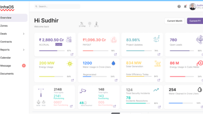
Data-Driven Decisions

Access actionable insights to make informed decisions at every step.

Discover how InfraOS can revolutionize your land development projects.

Revolutionizing Real Estate Development

Infraos is an AI-powered Agents coupled with SaaS platform that streamlines real estate and infrastructure processes, ensuring efficiency, transparency, and precision from land acquisition to financial automation.

15+

200

Trusted by Experts

Innovative Features

Notable features

Land Management
  • Land acquisition tracking.

  • Consolidation of land parcels.

  • Division into various land types: industrial, commercial, residential, and public spaces.

InfraOS is a robust platform that caters to comprehensive land and infrastructure management.

Cost Calculation
  • Real-time calculation of IDC (Infrastructure Development Charges).

  • Real-time calculation of EDC (External Development Charges).

  • Transparent cost allocation for land parcels.

Volumetric Analysis
  • LiDAR-based drone scanning for soil movement.

  • Calculation of soil displacement and deposition volumes.

Compliance Management
  • Automated tracking of compliance with authorities’ requirements.

  • Real-time updates for compliance documentation.

Drone and GPR Data Integration
  • Utilizes Drone and GPR technology for precise data collection.

  • Creates detailed and up-to-date GIS maps.

  • Facilitates 3D mapping for terrain analysis and land optimization.

Billing Automate Module
  • Automated generation of invoices for land development activities.

  • Integration of cost components like IDC and EDC into billing workflows.

  • Real-time, transparent financial reporting for stakeholders.

Customer Update Module
  • Real-Time Notifications: Keeps customers updated on project milestones, land status, and compliance progress.

  • Customizable Alerts: Tailored updates via email, SMS, or in-app notifications.

  • Progress Dashboards: Dedicated portal for customers to track real-time updates and project details.

  • Transparency: Provides clear insights into costs and compliance statuses.

Project Optimization Tools
  • Centralized data management for all land development activities.

  • Insights to optimize land utilization, process efficiency, and cost-effectiveness.

  • Streamlined workflows for large-scale projects.

Innovative Real Estate

Transforming infrastructure development with AI-powered solutions for efficiency, transparency, and precision in processes.

Comprehensive Compliance Management

Streamline compliance tracking and management to ensure regulatory adherence throughout your projects seamlessly.

A cityscape with a real estate sign in the foreground, prominently displaying the name and phone number. Surrounding the sign are various buildings with different architectural styles, some with scaffolding and green netting. The scene features a mix of older, worn structures alongside modern glass-fronted buildings. Power lines and construction materials add to the urban complexity.
Real-Time Budgeting

Manage budgets in real-time, enabling precise financial tracking and automated contractor payouts effortlessly.

Empowering Stakeholders

Tailored dashboards and predictive analytics provide stakeholders with insights for informed decision-making.
Aerial view of a residential area featuring multiple large apartment buildings arranged in a grid-like pattern. Cars are parked along winding roads, and pathways connect the buildings with patches of grass and bare land visible throughout. Roads and infrastructure border the residential complex, with snow patches indicating a cold season.
An aerial view of a developing urban area featuring several high-rise buildings under construction. The surroundings include a network of roads, greenery, and scattered residential and commercial structures.

Innovative Projects

Transforming real estate with AI-driven project management solutions.

The image shows an aerial view of a construction site with several multi-story apartment buildings at different stages of completion. The buildings are arranged in rows with some fully constructed and others partially built. The surroundings include green areas and a residential neighborhood in the distance.
Land Acquisition

Streamlined processes for efficient land acquisition and compliance.

A 3D rendering of a microchip with the letters 'AI' prominently displayed on its surface, set on a dark, circular platform.
Financial Automation

Automated financial processes for precise budget management.

An urban landscape featuring a large residential building with multiple windows and balconies in the background. Several construction cranes rise into the sky, indicating ongoing development or construction. The foreground shows a rooftop with industrial equipment, including vents and ducts.
A construction site features multiple rows of newly built, unpainted apartment buildings made of concrete. Heavy machinery, including excavators, is visible around the site. The backdrop includes a suburban area with residential homes and a forested area extending into the distance.
Progress Tracking

Real-time tracking of project milestones and contractor payouts.

Predictive Analytics

Empowering stakeholders with data-driven insights for decision-making.

woman wearing yellow long-sleeved dress under white clouds and blue sky during daytime

Infraos transformed our project management, making processes seamless and efficient. Highly recommend their platform!

John Doe

An aerial view of a residential area under development. Multiple multi-story apartment buildings dominate the scene, aligned in a row along a newly constructed road. Surrounding these structures are patches of green forested areas and open fields. A mix of construction sites and completed buildings is visible, along with some smaller houses with orange rooftops. The landscape extends into the distance with clear blue skies above.

The integration of GIS and drone data has significantly improved our tracking and compliance management.

Jane Smith

An aerial view of a modern urban landscape featuring high-rise buildings, intersecting roads, and elevated railways. In the center is a multi-use sports court surrounded by greenery. The architecture showcases a mix of residential and infrastructural elements, efficiently utilizing the available space.
★★★★★
★★★★★